![Map Of Trinidad Chart / Poster / Teaching Aid [Size: 30" x 20"] Smarter Choice!](https://studeemonkey.com/wp-content/uploads/2023/08/33746.jpg)
![Map Of Trinidad Chart / Poster / Teaching Aid [Size: 30" x 20"] Smarter Choice! - Image 2](https://studeemonkey.com/wp-content/uploads/2023/08/33746-1.jpg)
![Map Of Trinidad Chart / Poster / Teaching Aid [Size: 30" x 20"] Smarter Choice! - Image 3](https://studeemonkey.com/wp-content/uploads/2023/08/33746-2.jpg)

Description
Introducing the Map Of Trinidad Chart / Poster / Teaching Aid [Size: 30″ x 20″] Smarter Choice!
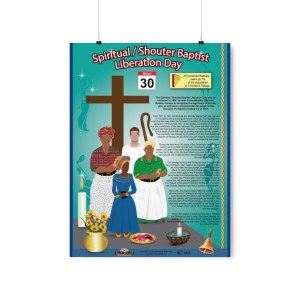
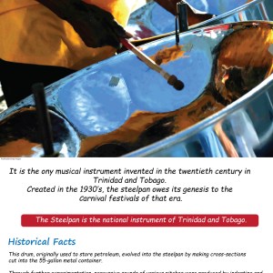
Discover the vibrant destination of Trinidad like never before with our Map Of Trinidad Chart / Poster / Teaching Aid! This intelligently designed educational tool is the ultimate companion for any social studies enthusiast, providing a comprehensive overview of the diverse landscapes, historical landmarks, and cultural icons that make Trinidad a true gem in the Caribbean. Available Online Only (AOO)!
Measuring at a generous 30″ x 20″, this chart is more than just a decorative piece – it’s a window into the heart and soul of Trinidad. Whether you’re a seasoned traveler, an aspiring geographer, or a curious learner, the detailed map is sure to captivate your imagination and inspire new adventures.
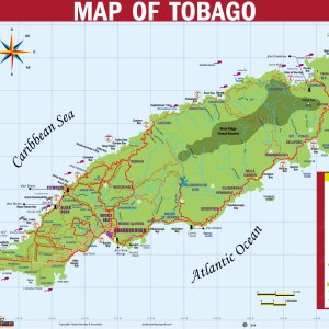
Embark on a visual journey as you trace the winding rivers, marvel at the majestic mountains, and explore the bustling cities depicted on this map. With utmost accuracy and attention to detail, each geographic feature is expertly rendered to provide an authentic representation of Trinidad’s awe-inspiring natural beauty. Feel the excitement rise as you follow the paths that weave through the island’s enchanting rainforests or uncover hidden treasures along the pristine coastlines.
Designed with educators in mind, our Map Of Trinidad Chart / Poster / Teaching Aid is an indispensable resource for classrooms. Engage students in interactive lessons as you highlight various points of interest, cultural traditions, and historical events. Watch as their curiosity flourishes, connecting the dots between past and present, and fostering a deeper appreciation for the rich tapestry that defines Trinidad’s heritage.
Key Features:
- Accurate depiction of Trinidad’s geography
- Detailed cartography with labeled landmarks and cities
- Captivating visuals showcasing natural wonders
- Size: 30″ x 20″ for easy classroom display
- Perfect resource for social studies lessons and projects
Unlock the wonders of Trinidad with our Map Of Trinidad Chart / Poster / Teaching Aid [Size: 30″ x 20″] Smarter Choice! Embrace the opportunity to explore, learn, and ignite the imaginations of students and enthusiasts alike. Order yours today!

![The Presidents of the Republic of Trinidad and Tobago, (2023 - 2028) -🇹🇹 [Chart, Teaching Aid, Poster] Size: 25](https://studeemonkey.com/wp-content/uploads/2023/01/Presidents-Chart-2023-100x100.jpg?crop=1)
![The Prime Ministers of Trinidad and Tobago - [Chart, Teaching Aid, Poster] 🇹🇹 Size: 25](https://studeemonkey.com/wp-content/uploads/2023/01/img_6564-100x100.jpeg?crop=1)

Reviews
There are no reviews yet.